Consequences of unckecked and illegitimate encroachment on these precious lake openings. BELOW - WHAT WE NEED!

Sunday 14 October 2012

HERITAGE REPORT GOES BACK TO PLANNING AND GROWTH COMMITTEE - STILL LOOKING GOOD!


The “Official Plan Five Year Review: Official Plan Amendment to Adopt New Heritage and Public Realm Policies” report went to the City’s Planning and Growth Management Committee last Friday (October 12th, 2012) Item PG.18.2. 
 
This follows the September 10th Public Consultation/Open House and the pursuant consideration of the report by the Toronto Preservation Board on October 1st when some minor changes were made to the original.

The changes that are important to us relate to the preservation of Views of Important Natural Heritage Features – Lake Ontario.  There are three changes (page 32 of the report):
  • The word “View” has replaced “Vista”.
  • Tenth Street has been dropped from the list and Fifth, Sixth and Twelfth have been added.
  • The view descriptions now include where the view originates i.e. the Fourth Street view of lake Ontario is from “just north of Lake Shore Drive”.
A supplementary report to the main report included this submission with regard to “specific views” ...
“Requests for several additional views to be included in the Official Plan have been made”
The Heritage Staff response to that is ….
“Given the current time line for the adoption of the OP policies, these views cannot be reviewed and verified at this time.  Staff will consider all requested views of the lake as part of a future study already requested by Council.  Opportunities for the consideration of other views may be sought through various planning studies”.
This refers to Councillor Milczyn’s motion and other concerns the community has with regard to the “windows on the lake” west of Sam Smith Park not being included on the list.  There is clearly need for more work and follow-up here.

On Friday, the Planning and Growth Management Committee deferred consideration of this report until January 28th, 2013 (Item PG.18.2).  They did this because some lawyers representing development interests wanted some tweaking of definitions and view corridor descriptions of a few historic buildings only (Queen’s Park, Casa Loma, Old and New City Halls).  No issue was expressed by any deputant with regard to views of natural features.

The meeting concluded with the Chair (Milczyn) and other members confirming that the PGM Committee must pass it in January so that it can be sent on to Council for adoption without delay.  The province has changed some heritage regulations and the OP is required to reflect those changes as soon as possible.


Monday 17 September 2012

COUNCILLOR GRIME'S MOTION TO ETOBICOKE YORK COMMUNITY COUNCIL - SEPTEMBER 2012

On September 11th, 2012, Etobicoke York Community Council adopted and delegated the following motion ......

1.     Request the Director, Parks Development, Etobicoke York District, in conjunction with the Director, Transportation Services, Etobicoke York District, to review and consult with the local community to identify sites which are unimproved road allowances in Ward 6 that abut Lake Ontario and offer a view or access to the lake or lake shore.  The review to consider if any existing encroachments are detrimental to community access to the lake, if these road allowances can be transferred to Parks, Forestry and Recreation Services for public park purposes.  Staff to report back to the Etobicoke York Community Council on the findings and recommendations of the review.

2.     Direct that no further encroachments be considered on unimproved road allowances abutting Lake Ontario in Ward 6, until this review is complete.

3.     Direct that the review be undertaken with consideration to existing Official Plan Policies, Heritage Landscape Polices, Vista and View corridors.


     The origin of the motion was a letter from Councillor Grimes dated June 18, 2012. 

Here is a summary of that letter ......

In Ward 6, which has the longest piece of the City waterfront in one ward, there has been an ongoing concern for decades to ensure that public access to the waterfront is ensured and enhanced wherever possible. In the 1990's The City of Etobicoke adopted the Windows to the Lake polices to preserve and enhance waterfront views and access. These windows were primarily unimproved road allowance on residential streets that end at the lake.  Many of them also have storm water sewer outfalls as well.

Over the last 20 years, as these pieces of land are primarily road ends, rather than officially designated parks, they have become encumbered with encroachments, which are now a growing issue amongst  local  residents who are concerned that the public view of the waterfront is being adversely affected. These encroachments include the placement of Canada post boxes, various utilities, and other structures.

The Waterfront trail, greatly used by cyclists and pedestrians alike, passes by many of these road ends. In some instances, they are the only park like setting on a residential street.

The road ends are now under the jurisdiction of Transportation Services and as such fall under the new streets by-law, but in some instances the Parks department maintains them.

HERITAGE OPEN HOUSE - SEPTEMBER 10TH

Last Monday (September 10th, 2012), City staff held their open house/public consultation on the proposed revisions to the Heritage policies in the City's Official Plan.  The report still lists views of natural heritage features to be preserved, including views of Lake Ontario from 2nd, 3rd, 4th, 10th, 11th streets, Miles Road, Lake Crescent, Royal York, Norris Crescent and Sand Beach RoadThe report can be viewed at this link.
There was opportunity for the public to comment by putting post-its on the boards.  All displayed comments regarding protection of these views were extremely favourable as were the results of conversations with three Heritage senior staff (apparently the word "vista" has been dropped  because of multiple meanings).
All being well, the report, including Peter Milczyn's motion, goes back for consideration to Planning and Growth Management in October where it will be recommended and passed on to City Council in the same month for adoption.
After that, the preservation of views of cultural heritage landscapes will become "officially" part of the City's Official Plan.
Here are photos of some of the boards that were shown to the public.  


Wednesday 5 September 2012

PUBLIC CONSULTATION FOR INPUT IN TO PROPOSED HERITAGE POLICY REVISIONS (LAKE VISTAS)


Heritage Open House – Proposed Official Plan Policies, Official Plan Review

Please come to learn about and comment on the proposed new heritage policies for Toronto’s Official Plan. You can read more about them at this link: 
Monday September 10, 2012
6:30 pm to 9:00 pm
Room 308-309
Metro Hall, 55 John Street (southeast corner of John and King Streets)

for further info.

Tuesday 17 July 2012

CITY COUNCIL ADOPTS HERITAGE REPORT

On Thursday, July 12th, 2012, City Council voted unanimously to adopt the Heritage Report which included Councillor Milczyn's motion (see previous post).


It also included a very minor amendment put forward by Councillor Ainslie that calls for more public input in to heritage designations through a Community Preservation Panel.


You can view the motions and votes that went along with this item here (PG 16.10).


City Council has directed staff to conduct a public open house on the proposed Official Plan heritage policies in September of 2012.


More on that to follow.

Wednesday 20 June 2012

PLANNING AND GROWTH MANAGEMENT COMMITTEE MEETING JUNE 18TH 2012

The heritage report that includes a listing of "views of natural heritage features" (Fourth Street is on it for its lake vista) was passed by the Planning and Growth Management committee on Monday, June 18th, 2012.

It was item 16.10 and the minutes and follow-up can be tracked here


The heritage report will be aired at an open house on September 10th, 2012 and should go to full City Council for approval in the Fall.  If it passes, it will become a permanent revision to the City's Official Plan.


Peter Milczyn, the PGMC chair, also put forward this motion that will go before City Council on July 11/12, 2012.  He said that it would start the ball rolling to provide stronger protection for lake windows than just heritage designations alone.


Tuesday 19 June 2012

EXCERPT, INCLUDING MAP, FROM THE HERITAGE REPORT

The full report can be read here
Revised View and Vista Policies Section 3.1.1
Delete Policies 8 and 9 of Section 3.1.1, replace them with the following and re-number subsequent policies.
8. Scenic routes are streets that provide public views of important natural or human-made features. The views from these scenic routes should be preserved and, where possible, improved by:
a) Maintaining and enhancing views and vistas as new development occurs;
b) Creating new scenic routes and/or views when an opportunity arises; and
c) Increasing pedestrian and cycling amenities along the route.
9. Public works and private development will maintain, frame and, where possible, create public views to important natural and human-made features from the public realm. The visual integrity of views and vistas of important buildings and structures, the downtown skyline, and important natural heritage features shown on Map (See attachment 2) will be protected and preserved The City will seek to ensure that new buildings, building additions and structures, and public undertakings do not obstruct or detract from these significant views and vistas. The retention of the integrity of the significant view vista shown on Map (see attachment 2) will be an important element of the consideration of such a development application or public undertaking. Where a development proposal may obstruct or detract from the visual integrity of views and vistas shown on the map.
FOURTH STREET IS SHOWN AS ONE OF THE GREEN ARROWS BETWEEN HUMBER BAY AND SAM SMITH PARKS

MILES ROAD RESIDENT'S LETTER TO MAYOR FORD - CONTAINS HISTORY OF ACTIVITY AT THEIR LAKFRONT PARKETTE


Dear Mayor Ford:

We are residents of Miles Road, which is located in the west end of our city. It is located at the edge of the Mimico 20/20 area. We are writing to you in order to call to your attention an ongoing issue regarding our Miles Road Parkette, which is located at the end of Miles Road, on the waterfront.

The waterfront view of our city line, from this Parkette is probably one of the most beautiful views in the city, and is enjoyed by our street as well as many others within our surrounding community and beyond.

Since 2005 a group of Miles Road residents have worked together in cleaning up our Parkette as well as planting some perennial flower gardens. We have contacted our Councillor, Mark Grimes (Ward 6), for assistance with various issues regarding the Parkette such as;

1. The installation of a protective railing at the top of the sewer outfall for the safety of anyone visiting the Parkette; (DONE)
2. Opening up the entrance to the Parkette so that it is wheelchair accessible; (DONE)
3. Two new benches , a concrete pad for the benches and a chess table; (DONE)
4. A Miles Road Parkette sign;(DONE)
5. Proper garbage containers and regular pickup of garbage; (DONE)
6. Adding more filler to the break wall ; and
7. Request to establish and define the proper property lines of the Miles Road Parkette.

It is important to understand the driving force to our commitment to clean-up this Parkette. The following points demonstrate this reasoning;

1. There was a slop just above the sewer out-fall which became slippery during times of rain or snow;
2. During the summer of 2004, we had observed a child in a wheelchair and his care giver taking their daily walk down Miles Road but they could not access the lake front because of the guardrail that stretched all the way across the Parkette area;
3. The original bench was an old broken bench with only one board left and hence was not safe for sitting;
4. Clear signage and clean-up of the overgrowth was required so that the Parkette could be returned to the community for its use, rather than be used for illegal purposes;
5. An old barrel was the container used for garbage and was seldom emptied by the city;
6. The current break wall has sustained some severe erosion and therefore should be enforced with some kind of filler to ensure it continues to be safe for the high traffic the Parkette sees, particularly in the summer during the fireworks and airshows; and
7. Because of the very popular use of the Parkette all year, it is imperative that the City stop the encroachment of this Parkette by the adjacent property on what is clearly City property.


To all of the above points our councillor and various City departments have assisted our community to the best of their ability. However, two items remain outstanding which require immediate action:

1) The break wall is matter of public safety and needs attention to ensure no injury occurs for which the City could be held liable.
2) The enforcement of the property lines adjacent to the Parkette. This is specifically pressing as one of the properties, #8 Miles, has currently set new post holes, beside an already existing illegal fence, that was installed many years ago and still stands. The action needs to be taken now, before the new fence is completed.

In closing, I refer you to the community meeting held at the Ken Cox Community Center on May 29th regarding the future plans for the Mimico 20/20 development, where one of the keynote speakers, Mr.
George Dark, talked about the importance of maintaining access to the lake and specifically the small roadways that dead end onto the lake with the parkland. With the development that is currently taking place within our waterfront, we are sure you recognize this extremely important asset to the community as a whole. As such we would appreciate your intervention in ensuring that the two outstanding
requests are addressed immediately.

Sincerely,
Miles Road Residents

Sunday 17 June 2012

TERRY'S DEPUTATION FOR THE PGM COMMITTEE


Deputation for: City of Toronto Planning and Growth Committee
June 18, 2012

Good Morning/Afternoon

My name is Terry Smith and I am a resident of Fourth Street in South Etobicoke and I am speaking on behalf of family, neighbours and myself.  We all live near the lake end of our street.

I have lived in the Lakeshore area for thirty years, am on the steering committee of Lakeshore Planning Council and I am a co-founder of Friends of Sam Smith Park. The Etobicoke Guardian elected me last year Urban Hero for the Environment.

We are delighted to see that the Toronto Preservation Board is here today to ask the committee to receive proposed Heritage Policy revisions to the Official Plan that include amendments to the View and Vista Policies section. We are even more delighted to see that, within that section, Fourth Street, our street, among others, is listed as an “important vista” on the Official Plan Map for Conservation and that the view of Lake Ontario from the bottom of our street should be protected as a view of “an important natural heritage feature”.

This is formal, official language for something that those of us who live on our street and in our lakeside community as well as the countless visitors who pass by on the Waterfront Trail already know in our hearts.  The spots at the road ends along our shoreline listed by the heritage staff connect us to the lake and provide small, intimate opportunities for interaction with the water.  We can see the lake, hear the lake, the birds, the waves, the creaking of the ice in winter, watch the storms approach, taste the coolness in the air, the fog, marvel at the view of downtown and the Toronto islands across the bay, the kayaks and sailboats or simply experience on a warm, still day the close, comforting, presence of the water that soothes our souls with its natural beauty. These are places where there once were public swimming beaches and fishing holes, piers, picnic spots, places where people launched canoes.

Visual and physical access to the lake is our heritage, both natural and cultural.  The very historical identity of Long Branch, New Toronto and Mimico - the Lakeshore - is rooted in our connectivity to the lake.

But these spots have long been under threat.  Although they are public lands - road allowance - there has been widespread, ongoing encroachment by adjacent property owners for years. Virtually every waterfront road end has some degree of encroachment. 

Our street, Fourth Street, is a particularly egregious example.  Hundreds of square meters of public waterfront land and tens of meters of shoreline have been appropriated for private use for decades.  Fencing initially and, in recent years, tall, impenetrable shrubs have brought about privatization and severely limited public access to the lake at our road end.

In the 90’s, the City of Etobicoke initiated a policy called “Windows on the Lake” to cover improvements along the Etobicoke sections of the Waterfront Tail.  Staff identified lakefront road ends and earmarked them for development as lake windows for the community and trail users once unauthorized private use had been resolved and encroachments on public land cleared. Fourth Street was to be the first lakeside parkette on the list to be developed and a survey and landscape design were duly completed.

It might be interesting here to quote Mr. Riley, Etobicoke Parks Commissioner at that time, from his July 1994 report to Council.  “In order for the City owned property located within lakefront road ends to be available to all residents of Etobicoke in an equitable manner, the removal of all unauthorized private encroachments must be achieved.  The public’s full enjoyment of the Lake Ontario waterfront must be pursued in earnest”.  This report and others like it were all adopted by Etobicoke City Council whose intentions and values were very, very clear, as Councillor Milczyn will no doubt recall.

Then amalgamation happened and the visionary “Windows on the Lake” initiative seemed to evaporate.

But, thankfully, here it is again today in a different, wonderful form.  We have a second shot at it, another opportunity to identify and protect lake windows, to bring the city to the water and the water to the city in as many places as possible.  Who knows, with will and foresight, maybe one day these places will all be connected by a continuous waterfront trail as well.  Maybe we’ll be swimming and fishing again in these spots with the water becoming increasingly cleaner as the City continues to tackle storm water management in the west end.

We urge the City to identify all the potential lake windows along all of our shoreline, firmly and finally enshrine their heritage significance, see that encroachments are removed, develop plans for building parkettes at these road end locations and, very importantly, transfer responsibility for them from Transportation to the more appropriate Parks Department so that they can be protected, valued and maintained forever. The community is happy to work with the City in any capacity to bring this about, including fundraising and stewardship.

We applaud the recommendations and background report from the City’s Planning staff and encourage this committee to accept and support them.  We look forward to the public consultation this coming September. 

Thank you for giving me an opportunity to speak today.

Terry Smith
64 Fourth Street
Etobicoke
416 251 5930


CCFEW'S PRESENTAION TOMORROW AT THE PLANNING, GROWTH AND MANAGEMENT COMMITEE AT CITY HALL

PG16.10 – Preserving Significant Views of Lake Ontario

Good Morning

My name is Brian Bailey and I am the President of CCFEW, Citizens Concerned about the Future of the Etobicoke Waterfront. We are a non profit community group formed in 1989 in response to the development proposals for Humber Bay Shores.

We are actively involved with the City and TRCA in the creation of new parks and in the improvement & maintenance of existing ones. We also provide monthly bird walks, and most recently are promoting and subsidizing nature classes in partnership with the Humber Arboretum in Colonel Samuel Smith Park.

Our main objectives are to:

• Promote a healthy waterfront environment through preservation and rehabilitation,
• To seek maximum parkland through the preservation of existing parkland on Etobicoke's waterfront, and the acquisition of additional waterfront and valley lands for park purposes.
• To promote meaningful citizen involvement in decisions affecting the environment.
• Ensure that any development or redevelopment is compatible with its surroundings in scope and scale

I am here today, representing our membership and the community of south Etobicoke. As many of you will know, David Crombie brought to our attention that Toronto had turned its back on Lake Ontario. A concerted effort was made across the Greater Toronto Area to reverse this situation and in the City of Etobicoke a number of projects and policies were implemented to help enhance and improve public access to the Lake.

We have been fortunate to achieve public access to the lake at Humber Bay Shores, through the redevelopment process, the Mimico Linear Park and Colonel Sam Smith Park. Most of this work was done in partnership with the City and the TRCA. We have also had improvements to
Marie Curtis Park and hope that through the Mimico 2020 work that Amos Waites park will be expanded and enhanced.

We are however concerned and dismayed that the initiative of the City of Etobicoke and the Regeneration Trust to implement and expand the Waterfront Trail has been discontinued. The creation of the Waterfront trail was to educate, inform and appreciate the Toronto waterfront
and to encourage the community to understand the importance of Lake Ontario, and the need to clean up the contamination being discharged into the lake, to support our birds and wildlife and in general have a safe, healthy clean waterfront for everyone to enjoy.

The City of Etobicoke adopted a number of polices to preserve and enhance what we called “Windows on the Lake” along the trail. These windows are for the most part road ends that go straight down to the lake and provide a visual view and access for the general public to the lake edge.

Half of these sites are now identified as significant views of Lake Ontario in the Official Plan's views and vistas policy.

Over the last fifteen years, and especially since amalgamation o Etobicoke into the City of Toronto, this initiative seems to have been forgotten. Over time a number of encroachments have been identified. In some instances it is telephone and mail boxes and utilities. Worst of all
are encroachments by the residents with the fencing off of city property, vegetation and privatization of the road ends.

We are here today because we have written to the City to ask for assistance but we have received no direct response or assistance.
We would like the City to remove the encroachments, expand and enhance the road end allowances (Windows on the Lake) and restore the public enjoyment of the waterfront trail which runs along Lake Promenade from the west to Lake Shore Drive in New Toronto and
easterly toward the Mimico Linear Park.

We know that the road ends are now under the jurisdiction of Transportation Services and we would like the road ends, most of which have sewer outfalls, to be rezoned into public open space, and transferred to the responsibility of the Parks Department to ensure their protection as Windows on the Lake.

Thank you for your time today. I would be glad to answer any questions you might have.

Saturday 16 June 2012

LINKS TO DOCUMENTS

Windows on the Lake
Documentation of this initiative from the former City of Etobicoke
(Fourth Street listed first in Phase 1)
1994-1996


Heritage Policies staff report
Proposed revision to the City's Official Plan with regard to heritage issues - the listing of "vistas of natural features of significant cultural heritage".
Fourth Street shown as a significant vista of Lake Ontario requiring identification and protection (page 22, map page 23)
June 2012


Sunday 6 May 2012

GOALS


Fourth Street Lake Window Community Group


Goals


  1. To remove the barrier of large shrubs on the Fourth Street, unnassumed road allowance which blocks the community’s visual and physical access to the lake and which encroaches on and, effectively, privatizes City land. 
  2. To create a community, lakeside parkette consistent with the existing plan already surveyed and designed for this location under the former City of Etobicoke’s “Windows on the Lake” initiative and which aligns with the City’s current Official Plan’s policies on waterfront open space.
  3. To have this Fourth Street Parkette designated an official park under the jurisdiction of the City of Toronto Parks Department with maintenance and stewardship shared by the community and the City. 
  4. To network with other groups along the shore who have similar encroachment issues at their lakefront road ends and work with them to bring about the development of more waterfront parkettes managed by City Parks through the implementation of the “Window on the Lake” initiative for all of South Etobicoke’s lake windows.

Sunday 29 April 2012

LAKE CRESCENT PARKETTE - WHY NOT ON FOURTH STREET TOO?

THIS
OR THIS!

WINDOWS ON THE LAKE SLIDESHOW - South Etobicoke (Click "full screen" for better view)


LETTER FROM OWNER 53 LSD DRIVE TO CITY OF ETOBICOKE REF PUBLIC ACCESS TO ROAD END


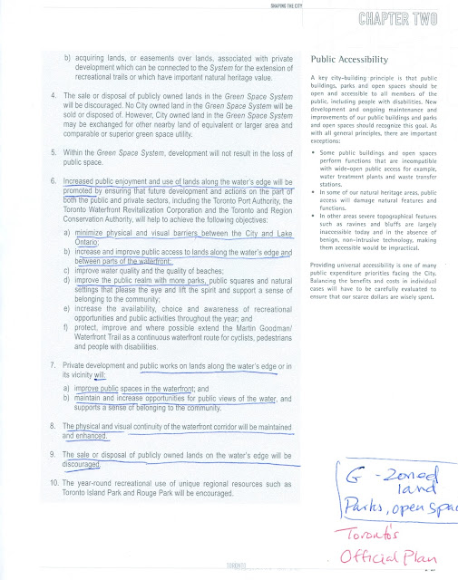
CITY OF TORONTO OFFICIAL PLAN - G ZONED OPEN SPACE

REMEMBER- OUR ROAD END IS ZONED "G", SHOWN AS A CONTINUATION OF PRINCE OF WALES PARK ON CITY ZONING MAPS

Link to Toronto's Official Plan
Section 2.3.2 "Toronto's Green Space System and Waterfront"- G ZONING

AMOUNT OF OF ROAD ALLOWANCE PRIVATIZED BY VEGETATION


1983 - FENCE - ORDERED REMOVED BY CITY BUT SHRUBS LEFT TO GROW


1994 - "WINDOW ON THE LAKE" PLAN - PETER MILCZYN


53 LS DRIVE PROPERTY BOUNDARY (METERS)


G ZONE CLOSE UP - CITY MAP


PRINCE OF WALES PARK - G ZONE CONTINUATION - CITY MAP


PROVISIONAL CITY CONTACT LIST


Mayor Rob Ford
mayor_ford@toronto.ca

Deputy Mayor Doug Holyday
councillor_holyday@toronto.ca

Councillor Grimes
councillor_grimes@toronto.ca

Councillor Peter Milczyn
councillor_milczyn@toronto.ca

Stephen Kodama, Director Transportation Services Etobicoke/York
skodama@toronto.ca

Al Smithies, Manager Right of Way Planning, Etobicoke/York
asmithies@toronto.ca

Don Pardoe, Supervisor of Right of Way Management
dwpardoe@toronto.ca

Richard Ubbens, Director Parks
rubbens@toronto.ca
  
Nick Garisto, Parks Planner, West District  416 394 8515

Councillor Berardinetti, Parks and Environment Committee
councillor_berardinetti@toronto.ca

Councillor Cho, Parks and Environment Committee
councillor_cho@toronto.ca

Councillor Kelly, Parks and Environment Committee
councillor_kelly@toronto.ca

Councillor McMahon, Parks and Environment Committee
councillor_mcmahon@toronto.ca

Councillor Moeser, Parks and Environment Committee
councillor_moeser@toronto.ca

Councillor Pasternak, Parks and Environment Committee
councillor_pasternak@toronto.ca

John W. Campbell, CEO, Waterfront Toronto
jcampbell@waterfrontoronto.ca

Christopher Glaisek, VP, Planning and Design Waterfront Toronto
cglaisek@waterfrontoronto.ca